Property Record
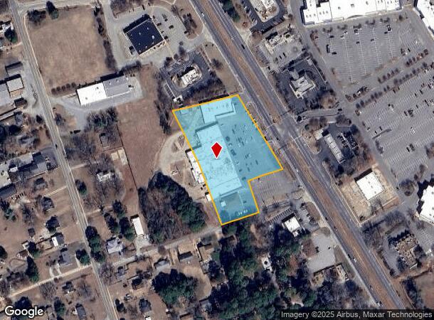
2348 George Washington Memorial Hwy, Hayes, VA 23072
NEARBY LISTINGS FOR SALE OR LEASE
Property Detail
2348 George Washington Memorial Hwy
27744
Plat: Pb6 188Pb3 22
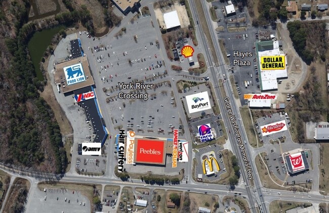
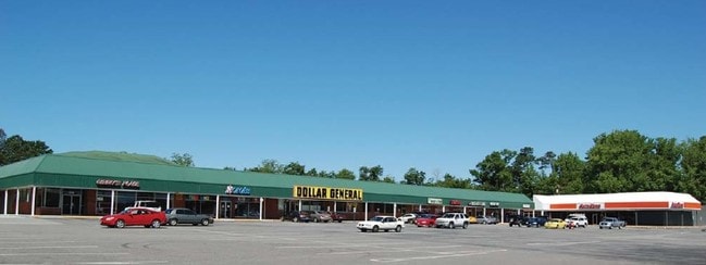
Stripcommercialcenter
HAYES BK B
X
Gloucester
51073C0120F
Virginia
2025
3.40 AC
2025
Gloucester
100301
Hampton Roads
45,236 SF
Virginia Beach-Norfolk-Newport News, VA-NC
DEMOGRAPHICS near 2348 George Washington Memorial Hwy
1 Mile
3 Mile
5 Mile
2024 Total Population
2,728
11,444
19,041
2029 Population
2,817
11,826
19,758
Pop Growth 2024-2029
+ 3.26%
+ 3.34%
+ 3.77%
Average Age
43
43
42
2024 Total Households
1,232
4,701
7,577
HH Growth 2024-2029
+ 3.25%
+ 3.25%
+ 3.68%
Median Household Inc
$60,606
$71,232
$73,185
Avg Household Size
2.20
2.40
2.40
2024 Avg HH Vehicles
2.00
2.00
2.00
Median Home Value
$258,884
$278,725
$296,130
Median Year Built
1979
1980
1982
Nearby Places
- Restaurants
- Banks
- Shops
- Fitness
- Groceries
PUBLIC TRANSPORTATION
AIRPORT
Newport News/Williamsburg International
DRIVE
WALK
Distance
Newport News/Williamsburg International
22 min
13.2 mi
Norfolk International
DRIVE
WALK
Distance
Norfolk International
54 min
38.6 mi
SALE & LEASE HISTORY
LISTING DATE
SALE/LEASE

Mar 30, 2017
For Lease
Nearby Properties
Address
Land Use
TOTAL SIZE
Lot Size
Zoning
Address
Land Use
TOTAL SIZE
Lot Size
Zoning
81,600 SF
21 AC
RESOURCE C
Address
Land Use
TOTAL SIZE
Lot Size
Zoning
54,032 SF
0.49 AC
SF-1
Address
Land Use
TOTAL SIZE
Lot Size
Zoning
57,012 SF
1.82 AC
SF-1
Address
Land Use
TOTAL SIZE
Lot Size
Zoning
1,876 SF
643 AC
SC-1
Address
Land Use
TOTAL SIZE
Lot Size
Zoning
46,690 SF
3.50 AC
YORKTOWN V
Address
Land Use
TOTAL SIZE
Lot Size
Zoning
19,301 SF
5.27 AC
YORKTOWN V
Address
Land Use
TOTAL SIZE
Lot Size
Zoning
86,535 SF
9.63 AC
SF-1
Address
Land Use
TOTAL SIZE
Lot Size
Zoning
30,160 SF
25.83 AC
B-1
Address
Land Use
TOTAL SIZE
Lot Size
Zoning
43,755 SF
0.92 AC
SF-1
Address
Land Use
TOTAL SIZE
Lot Size
Zoning
10,098 SF
10.50 AC
MF-1
Address
Land Use
TOTAL SIZE
Lot Size
Zoning
40,400 SF
0.55 AC
SF-1
Address
Land Use
TOTAL SIZE
Lot Size
Zoning
37,510 SF
11.59 AC
B-1
Address
Land Use
TOTAL SIZE
Lot Size
Zoning
43,716 SF
0.42 AC
YORKTOWN V
Address
Land Use
TOTAL SIZE
Lot Size
Zoning
14,814 SF
2.63 AC
B-1
Address
Land Use
TOTAL SIZE
Lot Size
Zoning
14,697 SF
6.47 AC
MF-1
Address
Land Use
TOTAL SIZE
Lot Size
Zoning
14,872 SF
2.80 AC
B-1
Address
Land Use
TOTAL SIZE
Lot Size
Zoning
21,752 SF
5.35 AC
YORKTOWN V
Address
Land Use
TOTAL SIZE
Lot Size
Zoning
39,198 SF
1.31 AC
YORKTOWN V
Address
Land Use
TOTAL SIZE
Lot Size
Zoning
9,220 SF
2.22 AC
C-2
Address
Land Use
TOTAL SIZE
Lot Size
Zoning
0.50 AC
YORKTOWN V
Address
Land Use
TOTAL SIZE
Lot Size
Zoning
40,720 SF
1.23 AC
B-1
Address
Land Use
TOTAL SIZE
Lot Size
Zoning
26,084 SF
1.52 AC
YORKTOWN V
Address
Land Use
TOTAL SIZE
Lot Size
Zoning
1,728 SF
1.34 AC
B-1
Address
Land Use
TOTAL SIZE
Lot Size
Zoning
8,745 SF
0.49 AC
YORKTOWN V
Address
Land Use
TOTAL SIZE
Lot Size
Zoning
16,399 SF
3.91 AC
SF-1
Address
Land Use
TOTAL SIZE
Lot Size
Zoning
2,554 SF
2.54 AC
B-2
Address
Land Use
TOTAL SIZE
Lot Size
Zoning
3,360 SF
7.22 AC
MF-1
Address
Land Use
TOTAL SIZE
Lot Size
Zoning
11,152 SF
5 AC
SF-1
Address
Land Use
TOTAL SIZE
Lot Size
Zoning
4,356 SF
17.65 AC
C-2
The World's #1 Commercial Real Estate Marketplace
Connect with us
© 2025 CoStar Group
The information above has been obtained from sources believed reliable. While we do not doubt its accuracy we have not verified it and make no guarantee, warranty or representation about it. It is your responsibility to independently confirm its accuracy and completeness. Any projections, opinions, assumptions, or estimates used are for example only and do not represent the current or future performance of the property. The value of this transaction to you depends on tax and other factors which should be evaluated by your tax, financial, and legal advisors. You and your advisors should conduct a careful, independent investigation of the property to determine to your satisfaction the suitability of the property for your needs.